Riding From Astoria to Manzanita – Our First Day On The Oregon Coast |
|
| xxxx | |
| Read about staging from San Jose to Astoria | |
| xxxx |
We intended to ride from Astoria to Manzanita. This was our first day back on tour. Intentionally, we deviated from the ACA Route, taking US-101 out of Astoria, instead of biking along Youngs River. Our deviation saved us four miles and 500 feet of climbing. Our principal reason for the deviation was a hope that we would see the Pacific Ocean, something that had eluded us on our tour of Washington State. We went through the first of Oregon’s two tunnels on US-101. We camped in Nehalem State Park, for the first time on tour.
Our Route
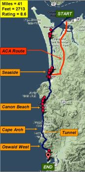
 We started our first day on the Oregon Coast at Astoria. We ended our day at Manzanita. We traveled 34 air miles, or 42 Surly miles. Our route was a blend of the ACA Route, and Vicky Spring’s route. We used our Garmin Edge 705, with preloaded TCX files, to guide us: 0.0 miles – START on US-101 (ASTORIA); 14.8 miles – RIGHT on 12th (SEASIDE); 15.3 miles – LEFT on Bike Path; 16.8 miles – LEFT on U; 17.2 miles – RIGHT on US-101; 23.3 miles – RIGHT on Fir (CANNON BEACH); 23.5 miles – RIGHT on 3rd; 23.6 miles – LEFT on Spruce; 23.7 miles – RIGHT on 3rd; 23.7 miles – LEFT on Hemlock; 26.5 miles – RIGHT on West; 26.5 miles – LEFT on US-101; 32.5 miles – TUNNEL; 39.9 miles – RIGHT on Manzanita (MANZANITA); 39.9 miles – LEFT on Classic; 40.5 miles – RIGHT on Ncarney City; 41.3 miles – RIGHT into Park; 41.5 miles – END (NEHALEM BAY STATE PARK).
 Through the course of the day, we would climb about 2700 feet. Three major climbs accounted for about half of the total, along with rollers and other inclines The first climb, just before Cannon Beach, was about 400 feet. The second and third climbs were about 500 and 450 feet each. They were closely spaced in a saddle., starting with the tunnel at Cape Arch.
Our Ride
Dawn came to Astoria, grey and threatening. The pavement was wet. Everything had a clammy feel. In some ways, it felt like the morning after the night before. At the end of the day, we talked with cyclists who camped at Fort Stevens during the night. They fought mosquitoes, drizzle, and wind all night. They spent their afternoon, the following day, trying to dry out their gear. We were just as happy to have had a roof and heater over our heads.
We bid farewell to David, who had a 13 hour drive ahead of him. He decided to take US-101 down past Seaside and go over to Portland and catch I-5. It was strange, watching him drive away. His words, “You can still call this off,” were echoing in our ears. The brave adventurer would never admit to such temptation. David covered the same route we took down to Seaside, in 20 minutes, that would take us hours.
We set out, dodging the traffic turning to take the ramp to the Megler Bridge, safely made it through the rotary before the Warrenton Bridge, and crossed over. Reaching the other side, we pedaled along wide, clean shoulders. We looked forward to getting clear of the grey skies and threatening drizzle. We began to acclimate to that vulnerable feeling, with traffic whizzing by, grey skies, and an uncertain road ahead of us.
I forgot to turn on my Garmin, at the start of the day. We had been pedaling for some time before I noticed. Marian joke that my ride didn’t count for me, and that I should go back and redo it. I asked her if she would wait. She shook her head. So, we rode on. With the Garmin now on, I could see the blue of the Pacific tantalizingly close on the map. However, it was always behind dunes, or tree lines, on the edge of someone’s farm or mini-estate. We didn’t get a clear view until we reached Seaside. The ride was very gentle, and Monday morning traffic was light, as was the mist.
Seaside
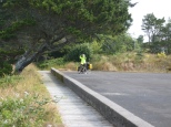
![]() Turning off US-101, we got our first good look at the Ocean. We pulled out our cameras and began clicking away. We were at the mouth of a small river. Oregon has many rivers running into the sea. California has almost none. Seaside showed us our first river in Oregon. The river had many sweeping turns, with a wide delta, before finally reaching the sea. These twists and turns, mudflats at low tide, were usually windswept, devoid of trees.
Turning off US-101, we got our first good look at the Ocean. We pulled out our cameras and began clicking away. We were at the mouth of a small river. Oregon has many rivers running into the sea. California has almost none. Seaside showed us our first river in Oregon. The river had many sweeping turns, with a wide delta, before finally reaching the sea. These twists and turns, mudflats at low tide, were usually windswept, devoid of trees.
 Further back, the river outlet was usually well protected, populated with trees, brush, and buildings. The unceasing winds off the Pacific had sculpted the trees . I sometimes wondered if Bonsai Trees and bushes were originally trimmed to mimic nature.
 We rode through a hilly residential part of Seaside, looking of the bike path. We were happy to sail down a well maintained, wide path. From the north side, we quickly moved from sparsely populated dunes, into hotel row. Seaside was far more upscale than Astoria. Obvious money was everywhere, from the hotels, to the shops, to the cars parked on the streets. Seaside had even fewer non-office jobs than Astoria. We were only in Seaside for an hour, but the climate seemed warmer, sunnier, more cheerful.
 Near the center of the tall buildings, Seaside proclaims proudly that it is the end of the Lewis and Clark Trail. We wondered about this. Numerous signs, to the south advertised more of the Lewis and Clark Trail.
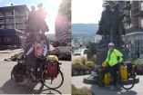
We learned something about our cameras. Our old camera seemed to do well in all light conditions. In poor lighting conditions, the sun behind the subject, the iPhone did less well. We In these light conditions, the old camera performed better than the iphone did. Being the good tourists, we could not resist posing where, undoubtedly, millions of others had stood. Marian was still wearing her rain jacket, which helped her stand out.
It was still early in the day to eat lunch, so we found a Subway Shop nearby. The young man making our sandwiches treated us as exotic creatures, wondering how hard it was, and how many people actually did this. He told us he had hitch hiked across the country. We encouraged him to try biking, telling him that, if we could do it, anyone could do it. He seemed doubtful. While we were there, we ran into other touring cyclists.
Canon Beach
We climbed our first big hill of the day, and coasted down the south slope to the Canon Beach exit. Our timing for lunch was perfect. We picked our way down into the town, swarming with cars and pedestrians. We found a little park, and settled in to eat. While we were there, we ran into Don and Naomi, a British pair. They were on the first leg of an around-the-world tour. They had started in Vancouver, and were working their way down to San Francisco. Because of the rain, they had spent two nights in Cannon Beach, and were preparing to leave town. We would see them again, as they passed us on a hill, and later, at Nehalem State Park.
 We finished our lunch, and threaded our way through heavy tourist traffic on the north end of town. Finally clearing it, we could get a clear view of the ocean again. We were quite near rocks poking out of the sea. According to Marian, they are haystacks. In fact, we were near Haystack State Park.
Cape Arch and a Tunnel
 Pushing on, we knew the hardest part of the ride was to come. Somewhere, up ahead, was our first tunnel. There were also two climbs between us and the campground.
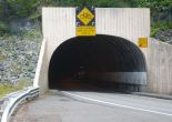
We reached the tunnel almost before we realized it. We were near Cape Arch. There was no fanfare, no sound effects, and no ominous mood music. We had moved some distance up the hill before we realized we were on the approaches to the tunnel. The grade was steep. I was the first to arrive, and had time to take a quick picture before Marian rode up and calmly pushed the button for the warning lights. We remembered the stories told to us, and tried to ride through as quickly as possible.
We expected a death-defying experience. We found ourselves pedaling up a steeper slope. I had imagined that tunnels were level. The shoulders were no better or worse than other roads we had been on that day. Traffic whizzed by in the on-coming lane. Traffic backed up behind us, and crept by us when it was safe. The tunnel was so noisy. Motor cycles were very noisy. The tunnel trapped the sound. It was deafening.
Popping out on the other side, I looked back to see another bike behind me. It wasn’t Marian. We stopped and introduced ourselves. Tom was a fourth year touring cyclist from Oakland. We congratulated ourselves on the tunnel, waiting for Marian to emerge. She did, safely. After catching our breath, Tom, pedaled on, soon leaving us behind on the climb. We did not know it, but we would see Tom, at Nehalem State Park, too.
Oswald West State Park
Entering the tunnel we started the second major climb. As we worked our way up, Don and Naomi slowly moved past us. Several other cyclists passed up. Marian and I climbed at different speeds. Her wheel size was slightly smaller, and I slowly pulled away. Over the course of a long climb, a gap of a couple of minutes would open. The trailing rider should not try to close the gap. The energy required is great, and makes no sense. We fell into a routine of a gap opening, and I would stop and wait for her. Sometimes she stopped when she reached me. Sometimes, because she had a goal in mind, or the grade was too steep for an easy restart, she would pass me. In fact, on some climbs, she rode further up hills without stopping than I did.
 At the top of the first climb, I began to suffer from low energy and dehydration. That me in a strange mental state. I knew this was happening, but I was not willing to take steps to mitigate it. In other words, I had become cranky. In the saddle, between the two hills, we stopped and rested. While it wasn’t a real concern, some part of me wondered how I was ever going to finish the last climb. Marian was very supportive. We did not leave until the sugar from the dates kicked in, and I was fully rehydrated.
 Still, the last climb was long, seeming unending. Our roles reversed. Marian led the way, and waited for me. I struggled on. I could not pull my eyes away from the Garmin’s elevation profile. This is like watching for the pot to boil. Biking and pushing, biking and pushing, we inched our way up that slope. Marian amazed me with her strength and positive spirit. It seemed like she pulled me up the hill.
 We finally got to the top. Our reward was a stunning view to the south. Of all the sights I saw in Oregon, this one was my favorite. First, because it was so beautiful. And second, because I had earned it.
Manzanita – Nehalem State Park
We zipped down the hill into Manzanita, stopping at the IGA store to get supper. We got directions, which, of course, included another hill. From there, we pedaled to Nehalem State Park. A sign, at the entrance, announced the park was full. Hoping that the tales of no cyclist ever being turned away were true, we stepped forward. There was plenty of room.
The ranger was friendly and efficient. He entered us into the Oregon computer system, and gave us a magazine listing each Oregon State Park. This has become one of those “don’t leave home without it” items. It gave clear information on each parks contact numbers, and directions. The only complaint we have is that the Hiker / Biker site, near the park entrance, was quite far from the restrooms, and even further from the showers. This was a common theme for other parks as well. Perhaps the Hiker / Biker sites were an afterthought. However, the difference between $10 for the two of us vs $30, and gaining entry vs being turned aside, was worth it.
Don and Naomi, and Tom greeted us. Also in camp was Emily, from British Columbia. They had been there for some time, drying out their gear. As we looked around, another couple was packing up their tent. They had parked their car a few miles away and biked in, to take advantage of the hiker / biker facilities. With a place to pitch our tent, we got about the business of getting everything out, showering, and making supper.
We were happy to share in the camaraderie of our fellow cyclists. But, being more tired than the young people, we opted not to take in the moon rise on the beach, and went to bed when the sun went down. I slept soundly
Our Thoughts
We completed our first day on the Oregon Coast. We, finally, got to see the Pacific Ocean. We planned our lunch time well, getting food in Seaside, and eating at around noon, in Canon Beach. We could have found a sandwich shop there, but we did not know where we would be when we needed to eat. Our first tunnel was interesting, but not terribly scary. We mastered three hills, although I, unexpectedly had a lot of trouble on the last one. We got to the camp ground with plenty of light. It was a good first day.
| xxxx | |
| Read about our ride shortened ride from Manzanita to Tillamook, and a trip to the Air Museum |

You must be logged in to post a comment.